Wednesday, 31 July 2013

An Unexpected Weekend Away


Earlier this month I was given an unexpected invitation to go to north Devon with my old Army Reserve unit, who were having an Adventure Training weekend. I had gotten in touch with them for something, and at the end of the conversation they had said "we're off this weekend if you want to join us?"  Of course I jumped at this chance, and once I'd figured out how to fit a mountain bike plus all the rest of my kit into the back of a tiny Toyota Aygo (no mean feat!) I was off.

We each got to do 2 activities, and I chose mountain biking - good preparation for my upcoming South Downs Way trip - followed by coasteering, which I hadn't done in a long time.

The mountain biking started well, following pretty difficult single track paths, with lots of rocks and drops to negotiate. There were also some really steep uphills to test the use of gears and leg strength. At one point someone broke a chain, so some bike first aid was required.

We didn't have time to do the full off-road route, so had to take a short cut back to the start point ready to switch activities. This road route seemed to include some of the longest hills in Devon - for one stretch we had 3km of uphill with no respite from the incline at all. A real leg killer, we were so relieved to reach the top after what had felt like hours of pedalling. I was pleased not to be at the back of the group, especially as this meant I got some time to catch my breath while waiting for the rest, but I could not keep up with the leader's punishing pace. The next 7km were all either downhill or on the flat, and whizzed by in about 10 or 15 minutes, making a real mockery of the uphill struggle. Sadly I took no photos from the mountain biking, as the only points where we stopped I was too busy either taking on fluids or energy sweets - or just trying to catch my breath.

Back at the minibuses, we had packed lunches and headed straight to the coast for a quick change into wetsuits and the next activity.

The coasteering, with our guides from Active Escape, was fantastic. The weather was glorious and sunny, which really took the edge off the cold sea, and after hours of hard work on the bikes it was nice to let the sea take the weight off for a while. The swimming also balanced out the leg aches by adding a good arm workout into the mix. I'm pretty nervous about jumping from a height, but love the buzz of adrenaline and the feeling of overcoming my nerves and getting braver with each jump. 

The guides even had a waterproof camera with them to capture a few action shots:


We swam around the coastline, climbing up various rocks in order to jump in. Getting higher and higher each time, you get more of a buzz as you do bigger and bigger jumps.


The tide was also right for our group to head to a few rock tunnels, and squeeze through with the sea swell assisting you if you time it right.

Of course our time was soon up, and we had to return to dry land, ready for dinner and a few beers.

I had to head back to reality the next day, but it had been great to get away briefly for some unexpected adventure.


Friday, 12 July 2013

On Yer Bike - Wildlife Rescue!


This summer I got back on my bike. My Specialized Rockhopper Comp mountain bike was a 21st birthday present (unconventional for a 21 year old woman maybe, but it was what I wanted!) but it has been sadly neglected the last few years.

With the Thames behind


When it became apparent that I definitely would NOT be able to go abroad to do the job I had trained to do I was absolutely gutted. I was also alone as my husband was already out there, and so I had no one to take pity on me if I wanted to sulk. So I had to stay positive, act positive, and take on a new challenge instead.

I had read about the South Downs Way the previous year and had thought that seemed like my kind of thing, so I decided to get back on my bike for fitness (unable to run due to a trochanteric bursitis / tendonitis I got during some training, that just will not settle down…) and have the South Downs Way as my goal.

Beginning on the roads I had a great time cycling through the Buckinghamshire countryside. I found new places, so picturesque. I found a lovely spot for a stroll along the Thames.


On one occasion I even spotted a gorgeous little Greenfinch fledgling stuck in the road. I could see it from some way back, struggling to get back up the curb from the road where it lay. Every time a car went by it flapped around in panic, and sometimes got sucked further into the road by the passing cars. And it could not get up that curb, the poor little thing!

When I got to it I got off the bike and used the front wheel as a shield to stop the bird from scooting into the road in panic. It stayed fairly still, so I let it rest a moment while I got my phone out - it was too beautiful not to get a picture! You really shouldn’t handle fledglings as normally their parents are around somewhere and will help them out once you’re out of the way. But this was a bit different – the bird was in danger from the traffic, and the constantly passing cars would make it impossible for the parents to get to it safely.

I’ve had a pet bird before and was pretty confident at handling this little Greenfinch, although I was worried how it would react as small birds can easily die from shock if they are handled. When the bird seemed calm I got my camera at the ready and firmly and gently grabbed hold of it, clicked one picture and put the bird in the nearby hedge. It did seem quite stressed which was upsetting, but I really hoped that it would recover itself and its parents would be with it again – and at least I knew it wouldn't be hit by a car now!


I did enjoy going around by bike, you do see so much more than when you whizz by in a car!


Friday, 21 June 2013

White Water Kayaking


When I still lived in West Wales I was very active in outdoorsy pursuits, and among these much-loved hobbies was kayaking. In the sea, in rivers, going from A to B or just surfing and trying to play boat - all of it was enjoyable for me!

Since going to Uni in 2002 I have rarely been out kayaking. I don't have the kit and I don't know other kayakers now, which all makes getting out on the water pretty difficult... However, finding a good course to go on at a much reduced last-minute price answered that problem very nicely!

Plas-y-Brenin, in North Wales' Snowdonia, offer last-minute empty spots on their courses at a bit of a discount - a wonderful fact I discovered while idly surfing the web, along with the discovery that a white water kayaking course taking place that weekend (meaning, I would leave the following day!) had such a discounted place available!! 

Snowdonia really is beautiful, and the idea of getting out and refreshing my white water skills while meeting like-minded people seemed a fantastic idea. I was still a bit nervous however, as it had been so long since I last paddled, but a quick phone call to the centre allayed my fears as they explained the level that this course was pitched at. 

The next day I loaded up the car and headed up to North Wales. I had a good drive up, and was quite excited when I arrived at Plas-y-Brenin. I had only ever driven past the place before, but on checking-in I discovered that the people were as friendly and welcoming as you would expect outdoorsy sorts to be, and the place itself was really excellent. Nice clean rooms with great showers, and a lovely bar where you could order some pretty good, hearty food on your first night - the food for the following days was included in the course price, along with the accommodation.

The first morning of the course, after a good safety and orientation brief, we met our instructor Karl and the rest of the group. Our group was really great - there was a young trainee teacher and her dad, plus another girl who was a newly qualified anaesthetist, as well as being a highly accomplished orienteerer and caver. Everyone had a great sense of humour, and we had a great time together.
We also had glorious weather, which meant some of the river levels were a little low; but we did get to paddle in spectacular sunshine - and it wasn't too cold if you got dunked :)

The first day we practiced a few white water basics in safer parts of the river - breaking in and out of eddies, ferry-gliding, shooting some small rapids and drops. Our instructor, Karl Midlane, was fantastic, and he even took plenty of great photos for us.


I was the most experienced paddler of the group, but I was also the longest away from paddling, so it was a real boost to find I could still paddle well, and I could even still roll, which was great! This had the added bonus that on the second day, the instructor allowed me to do a few larger, bumpier sections of rapids that the others couldn't - this wasn't being unkind in any way, it would have been too risky to allow people with uncertain support strokes and no roll to do sections where you could easily capsize into white water. It's a shame there are no photos of that bit - good as the instructor was though, even he couldn't paddle white water and take photos at the same time. Further along the river from here though, there were some smaller sections that we all paddled and got photographed:


At the end of that final day, I was allowed to have a play in a stopper. I didn't have particularly great skills, but getting stuck in there felt exhilarating - only two days previously I had been nervously asking whether I would be suitable for this course, and there I was with the power of the river all around me, making my kayak dance a little in the surging water, and then finally rolling upright again when I could no longer hold my own against nature and ended up floating away upside-down :)


Wednesday, 12 June 2013

Trip Planning - Cycling the South Downs Way


I have recently begun planning a multi-day mountain bike trip, to cycle the whole of the South Downs Way - a 160km (almost 100 miles!) trail of on- but mostly off-road cycling (advertised here).

I had heard about the South Downs Way quite a while ago and fancied giving it a go, but I didn't get the chance previously due to work commitments. Plus I was unable to take time off work outside of the stipulated holidays, meaning I couldn't organise anything at a suitable sort of time! I tend to worry that I won't go through with things, and finally having an opportunity I really didn't want to waste it. I therefore decided to advertise my trip on a forum called Explorers Connect, figuring that if other people joined me I was then committed and could not let them down.

Planning and effectively being the 'leader' for a trip like this feels a little daunting, but also very refreshing and exciting. The planning is going well too: so far I have recruited team mates, obtained all the route information & mapping, and made up a comprehensive kit list. We have a planning meeting tomorrow to firm up the details, so I'm really looking forward to getting together with everyone and seeing who these people are that have put their trust in me via the internet!

This trip will be unsupported meaning we will carry all our gear, and we will camp or bivvy for our overnight stops. This means that an important part of the planning will be kit selection, and in order to keep the weight down we will share equipment wherever possible, e.g. tent, jetboil, bike toolkit etc. - although we'll make sure we each have a toothbrush!


Don't worry - I have a bigger bag for the actual trip!


Thursday, 28 March 2013

Geographical Journeys at the RGS

Yesterday evening I had the great pleasure of attending an event at the Royal Geographical Society in London. I was very excited to be able to attend an event there, as the Society is obviously steeped in history and enshrines such famous names as Livingstone, Stanley, Scott, Shackleton and Hillary. Greats indeed in the history of endeavour and adventure.
The event I went to was about expeditions on a slightly more modest scale, but adventures none-the-less. And to make it all the more exciting, the reason that I was there was that one of the speakers was a friend of mine and she had invited me.

Geographical Journeys: Microlectures’ featured seven speakers who had all undertaken travel, either for exploration, science, work, or simply for the journey. Each speaker had only 10 minutes in which to deliver their adventure, and so we heard about how Emma Baker went to Sierra Leone on a volunteer program and had the experience of a lifetime, how Faraz Shibli and his girlfriend travelled to Laos with their new bicycles to travel the country. The cycle journey ended when his girlfriend injured herself in a fall and they had to turn to hitch hiking instead, but it was not all disaster as they got engaged on the trip! And Levison Wood told anecdotes of his journey to South Sudan, the World’s newest country, to lead a Channel 4 crew who were making a film about fishing in a war zone.

My favourite tales were those of: 
Keith MacIntosh, who did not cancel his trip to Ladakh, a mountain desert area high in the Himalayas where it never rains, when in the middle of the night a rare cloudburst event flooded the area causing massive damage to this rural, undeveloped region. Many inches of rain fell in minutes during this poorly-understood phenomenon, and the mountainous terrain funnelled the water into the valleys – exactly where the population all made their homes. The flooding and mud slides caused huge damage to homes, the minimal agriculture in the region, and uncountable loss of life. Keith still travelled to the area, but replaced trekking with conducting any unskilled labour he could to help the stricken area: repairing irrigation systems, helping bring in the harvest, clearing wreckage and recovering people’s belongings from the mud slides. He was also there when HH the Dalai Lama visited to unite the people and give them strength. Quite an experience!

Conservation biologist James Borrell, who told of his experiences conducting fieldwork in the remote and beautiful Dhofar Mountains in the Arabian Peninsula. This region is an oasis of jungle on the coast of Oman, near to the border with Yemen, where the limestone mountains drive moist air upwards creating jungle in the desert. Here the team collected valuable data on the surprisingly diverse wildlife, and with camera traps they captured images of rare striped hyenas, honey badgers, and even captured the elusive and enigmatic Arabian leopard, an extremely rare subspecies thought to number less than 250 individuals scattered across Arabia – even fewer than its more famous rare cousin, the snow leopard.

Malgosia Skowronska, a mountaineer from ‘Afghanistan’s Secret Peaks’ project who described her journey through mountain regions of Afghanistan’s Wakhan Corridor – the narrow strip of land at Afghanistan’s north eastern side, pointing out towards China to climb previously unclimbed mountain peaks. With modern-day Pakistan to the south and modern-day Tajikistan to north, this corridor was created when the British and Russian Empires created a buffer zone during ‘the Great Game’, and it is extremely remote. Malgosia showed wonderful photos of Wakhi and Kirgiz people, the women of these people unlike the common image of Afghan women hidden under burkhas, and instead resplendent in beautifully patterned and ornate bright red clothes and fancy jewellery. Afghanistan holds a special place in my imagination as I have been there with work and have spent a lot of time learning about culture there and also studying one of the Afghan languages, Pashto. I would love to visit the Wakhan area of the country, which has not been affected by the regime of the Taliban in the same way as other areas of the country.

The speaker I had been invited by was my friend Helen Spencer. Helen is fascinating. She loves travel and has been fortunate enough to do a lot of interesting trips – she has already been reindeer herding with the Sami people in Norway this year, and will be heading off on an Afghan adventure in the summer. Her work as a vet has also taken her to fantastic places and has had her working on incredibly interesting projects with different people around the world (Jealous? Moi??)

This talk was about the time Helen, as part of a group organised by specialist travel company Secret Compass, took part in the first recorded coast to coast crossing of Madagascar by foot, including summiting the highest mountain on the island (and the second highest by mistake too due to a slight misjudgement in calculations!)

Sambava on the east coast - journey's start (photo by Helen Spencer)


The expedition began on the east coast and moved west, initially on well-trodden tracks past local villages, camping in school fields or other open patches of land. The group were the first foreigners ever seen by most of the people they encountered, and they regularly drew large crowds of curious onlookers to watch them put up their tents, deal with their blisters, go for a wee in the woods…

A tea break with an audience of hundreds! (photo by Helen Spencer)


Eventually the paths petered out and the team moved into jungle that required them to hack their way through. Sometimes the undergrowth was so thick that they could only cover as little as 6km in a full day’s work. Navigation was seriously hampered as the close-up jungle obliterates landmarks and the dense canopy interferes with GPS systems, so the team used rivers where possible to aid their route finding. As they encountered more hilly terrain they broke in and out of jungle, getting treated to spectacular views that human eyes may never have seen before. Sorely needed compensation for the heavy packs, back breaking work, leeches, blisters and flesh eating parasites! 

Breath taking views (photo by Helen Spencer)

Making their way through the jungle (photo by Helen Spencer)
The Tsaratanana Massif region at the north end of the island contains, at 2,880 metres (9,449 ft), the highest point on the island. Not quite in the league of the Alps in Europe, though higher than our highest British peak of Ben Nevis. The team made their preparations for the summit, which included bringing a white chicken which they had carried in from the start of their journey. At the top the high fives were halted when the GPS revealed they had headed up the wrong peak, so down they had to traipse, across the boggy patch at the bottom, and back up the right peak.

The summit team at the highest point of Madagascar (photo by Helen Spencer)

More incredible views, possibly never seen before (photo by Helen Spencer)
 
Eventually, despite the inaccuracies of their 1962 French Foreign Legion maps, the whole team made it out of the jungle and down towards the western coast. No serious injuries were sustained during the trek, which was excellent luck as with no helicopters on the island, a casualty would have meant the team would have to carry them back through all of the difficult terrain they had already passed! (Now there’s an incentive to look out for your team mates!) That said, a few members did end up in the Hospital for Tropical Diseases with leishmaniasis – the previously mentioned flesh eating parasite, which is passed on by bites from sand flies. Yuk!


Journey's end on the west coast, and a well-earned rest for some tired feet (photo by Helen Spencer)

Becoming something’s dinner aside, imagine being the first to do something? The first to see that view, tread that path, make that achievement? Simply a-MA-zing.


Wednesday, 23 January 2013

Seven Sisters Weekend with Explorers Connect

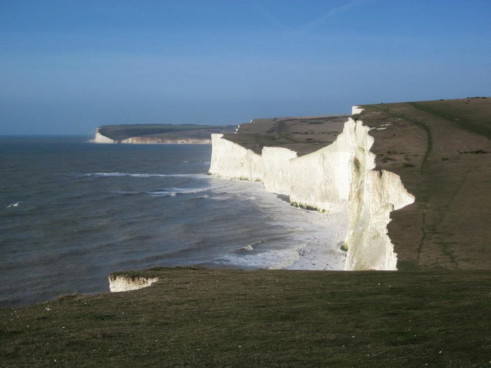
I am about to be alone for a long chunk of time as my husband goes off to work abroad, so as part of staying positive and making the best of things, I decide to book onto a trip with Explorers Connect to walk the Seven Sisters, a series of chalk cliffs on England's south coast.  I figure an outdoorsy weekend with like-minded people will help ease the loneliness, and give me something to look forward to during an otherwise difficult time.

Rather than driving, I opt to make it more of an adventure (and avoid London traffic) by taking the train from my local station, Beaconsfield, to Seaford on the south coast. From there I took a taxi the short journey to the Alfriston YHA, where our small group was booked in for the weekend. Heading to the local pub, the group eventually all arrives and we become acquainted over hearty food, good beer, and great stories.

Saturday morning is cold and clear, a relief after all of the rain we have had which led to sections of path being closed due to the water damage. We set out for a hike along the Sussex Heritage Coast, joining the coast at Cuckmere Valley and following part of the South Downs Way National Trail.


We hike along, pausing to take in sights, enjoying the famous white cliffs.


At Birling Gap we stop off to look at these houses. The soft chalk erodes quickly, particularly during any storms, and photographs from different years show the steady retreat of the cliff top. This terrace used to be much longer before houses were lost one by one to nature's destructive progress:


Further along, we pass these beautiful wild ponies, all shaggy and cuddly in their winter coats.


We encounter lighthouses too, both high on the cliff and closer to the sea.


The undulating cliff top path continues further, the weak winter sun giving atmosphere to the views.


Eventually we reach Beachy Head, the highest chalk sea cliff in Britain, and thus notorious as a site for suicides. 


Luckily it also has a pub, so we head there for food and refreshment before taking a more direct hiking route back to the YHA - and its own nearby pubs for dinner.


The next day, Sunday, is the final day of the weekend, and kayaking is on the menu. It is really cold, so we all wrap up warm. We have a choice of entry methods to get onto the river - I go for the seal launch down the wooden steps. Great fun!


We have a simple paddle up the river, with a short break on the bank before returning. 


Basic paddling, but good to be out and especially with such great company. This was definitely a good idea :)


Monday, 8 October 2012

Zarafshan and Iskanderkul


The second free weekend we had in Tajikistan saw us travelling further afield than last time, about 140km (approx. 87 miles) to Iskanderkul in the Fann Mountains. This might not sound a huge distance, but given the conditions of Tajik roads it is no mean feat.

Map from Google Maps. The pointer is at Iskanderkul


Rachel had organised things once again, and we had mini buses with drivers, a place to stay, and one of our local associates from Dushanbe had come along to help translate.

The roads were in poor shape much of the time, and the minibuses were not much better maintained, making for a long journey. Further delays had the potential to be more entertaining though, such as getting stuck in many traffic jams consisting mainly of sheep and goats!


The views from the window as we drove were fantastic.


The overheating minibus meant that we got to enjoy some of the views from outside too, as we waited for the engine to cool down from dangerously hot…


The further we got from the city, the more frequent were these tiny stone-built dwellings. Very quaint and picturesque to us as visitors, but can you imagine having to actually live there? Especially in the harsh snowy winters Tajikistan gets. The poverty here is something I have never experienced before, and while many in the group don’t seem to think about it, I find it very sobering.


After a long day of driving, we come to the Zarafshan Valley in north-west Tajikistan, in a mountainous region containing many mountain ranges (Zarafshan Range, Turkestan Range, Hisar range, Gissar Range, the Fann Mountains…)

ЗEраBшaн = Zeravshan


The floor of this glacial valley is dotted with more tiny stone houses, and the Zerafshan River snakes along the bottom.


Following the valley a while longer, we eventually reach our destination. The newly-built 2 storey wooden cabin is the pride and joy of its owner, and although I can’t understand his dialect it is written large in the proud welcoming smile on his face as he shows us around. The others are not impressed with the food that has been provided, but having witnessed evidence of the poverty in this country I am impressed and grateful at the thoughtful spread of Tajik sweets and fruits that await us. When the main dish is served, it is a traditional Plov cooked up in a homemade cauldron in the small kitchen at the top of the garden path. In poorer countries meat is often both prized and scarce, so while others again complain about portions I am again grateful. Not only for the food and the enthusiastic service, but also for the chance to sample genuine traditional cuisine from the region. 


After food there are just a few daylight hours remaining, so Rachel and I decide to go for an explore. Following the river away from the road, we enjoy the peace that the remoteness brings.


Soon we come to a bridge across the river, which we decide to take.


The field we find ourselves in contains this slightly rundown shepherding complex, with shelter for the animals and their human protectors.


We continue up a narrow track climbing the valley side, and keep going until we risk running out of time. We do stop for a short while, to absorb the view and to discuss the different travelling philosophies in the group (Rachel’s and mine are very similar) and to talk about the region and its culture, and the charm of the guesthouse we are staying at.


Then we must head back down so that we can get back before dark. Our sleeping area is simply the open-plan upstairs of the guest house, but it is surprisingly warm and cosy. There are no beds, instead we are each provided with sleeping rolls. I think they are made of felt, and while they don’t look like much my goodness they were comfy! I loved my sleeping roll :)


I get to see some wildlife too – someone knows I am keen on nature, and rushes to tell me about the huge moth in the bathroom. It’s beautiful, and bigger than my hand, but sadly something eats it during the night and by morning nothing is left but a few pieces of wings…


We only have a 2 day weekend here, so the next day we must return to Dushanbe. But not before our main excursion into the Fann Mountains, and the popular Iskanderkul Lake, named after Alexander the Great. 


We walk around the lake a bit, and follow a path along its outflow, Iskander Darya, which eventually joins up with the Zerafshan River we saw the previous day.


This turquoise coloured mountain lake lies at an altitude of 2,195 metres and is fed by glaciers, so when we return to its shores and go for a swim it is bloody cold! So cold that my body aches, and I can’t stand the pain for long so after a brief swim around I am out of there.


We all want to stay here longer, and several of us petition to be allowed to travel further, to the ancient town of Panjikent near the border with Uzbekistan. Unfortunately though we have work the next day, and the drivers are insistent that we must leave in time to return before dark. Having seen the state of some of the roads we know that this is sensible, and reluctantly we return to our vehicles for the trip home.

This trip has been far too brief, but very special.